
Wan Kasa Fm
Type Locality and Naming
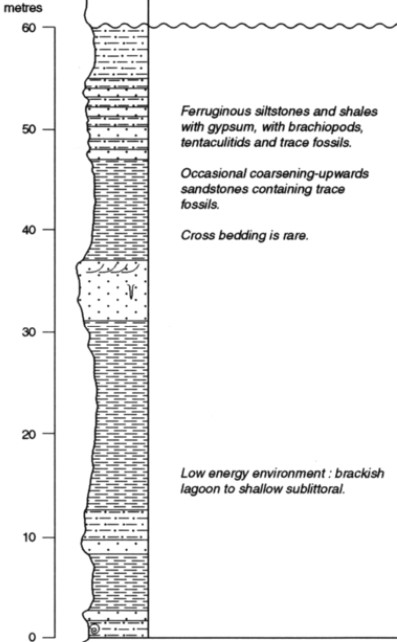
Wadi Wan Kasa in southwest Libya. Borghi & Chiesa, 1940. Reference section is at Gour Iduka in Wadi Wan Kasa in the Takarkhouri Pass in southwest Libya (Figure).
References: Borghi & Chiesa, 1940; Plauchut & Faure, 1959; Jacqué, 1963; Freulon, 1964; Klitzsch, (1969; Lababidi et al., 1985; Mergl & Massa, 1992, 2000; Mergl et al., 2001; Tawadros, 2011; Shalbak, 2015; Hallett, 2002, 2016.
Synonym: Spelled Wan Kaza on the Geological Map of Libya (1977) and Ouan Kasa in the 1985 edition. The former/improper spelling of the Formation was "Ouan-Kasa". The spelling was modified to its current form by Hallet (2002) after verifying the official name records of localities in Libya. Freulon’s (1964) "Séries du Djado" is synonymous with the combined formations of Tadrat and Wan Kasa.
[Figure. Stratigraphic column of the Wan Kasa Fm at the Type Locality in Libya (Source: Hallet, 2002).]
Lithology and Thickness
At Type Locality (Figure): Gray, partly silty shale interbedded with clayey siltstone and fine-grained sandstone with minor calcareous beds. In the Djado Basin: Fine-grained sandstones and calcareous sandstones (up to 25% carbonate), with several coquina horizons, indicate wholly marine origin. Thickness: 20-170 m at the Type Locality and up to 365 m in the subsurface.
Relationships and Distribution
Lower contact
Conformable onto the Tadrart Fm
Upper contact
Overlain by the Awaynat Wanin Fm
Regional extent
GeoJSON
Fossils
In the type section in Libya, a rich and diversified marine fauna was collected and described, dating a Late Pragian to Emsian interval [Brachiopods, Tentaculites, cephalopods and trilobites (e.g., Tropidoleptus carinatus Conrad, Chonetes orientalis Loczy var. admixta (Cowper-Reed)) as well as crinoids, corals, pelecypods, and plates from placoderm fishes.] (Mergl & Massa, 1992). A similar fauna, collected in the SW part of the Djado Basin, was also described (Mergl & Massa, 2000). The fossiliferous locality lies east of the Chirfa oasis (co-ordinates N 12°43’E 20°55’N). The distance between both localities is approximately 400 km.
Age
Depositional setting
Continental to shallow marine at the Type locality; Marine in the Djado Basin. Extended regional and continuous open marine character of the late Early Devonian is well established along the western margin of the Djado Basin.
Additional Information